www.duckcreek.org - new hosting server 05/30/2004
Pre-Interstate Urban Archaeology
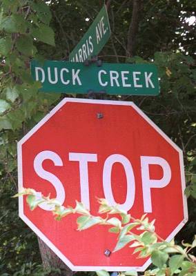
Duck Creek Road
Cincinnati and Norwood, Ohio

|
www.duckcreek.org - new hosting server 05/30/2004 Pre-Interstate Urban Archaeology Duck Creek Road Cincinnati and Norwood, Ohio |
|
 |
 |
|
|||
 |
 |
|
|||
 |
 |
Updates
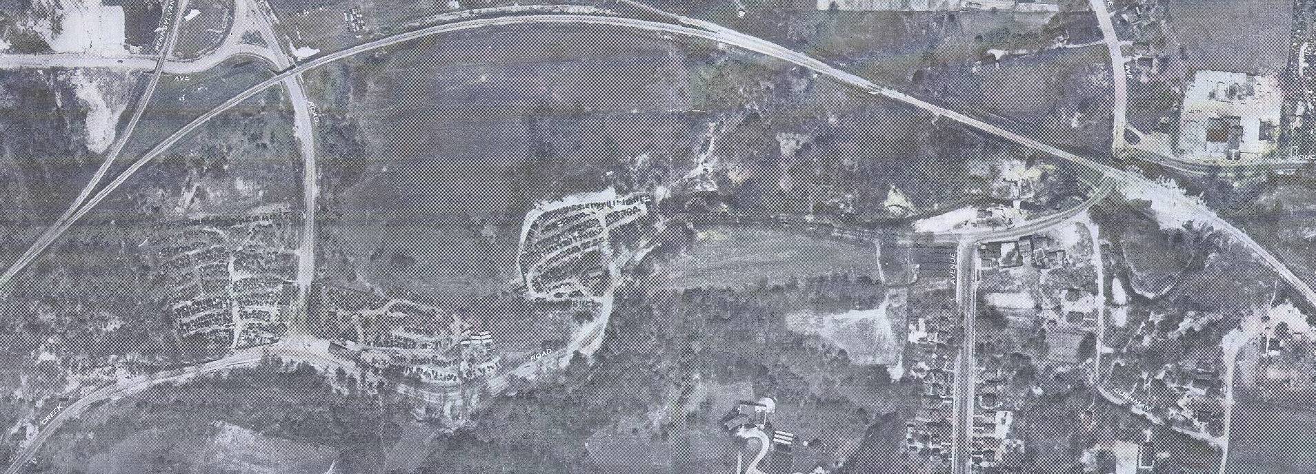
This was fun to make and will be even more fun when all of the 1948 Fairchild panels are scanned and pasted together. This seemed like the best way to illustrate what can be seen today, using the 2000 Terra as a base image.
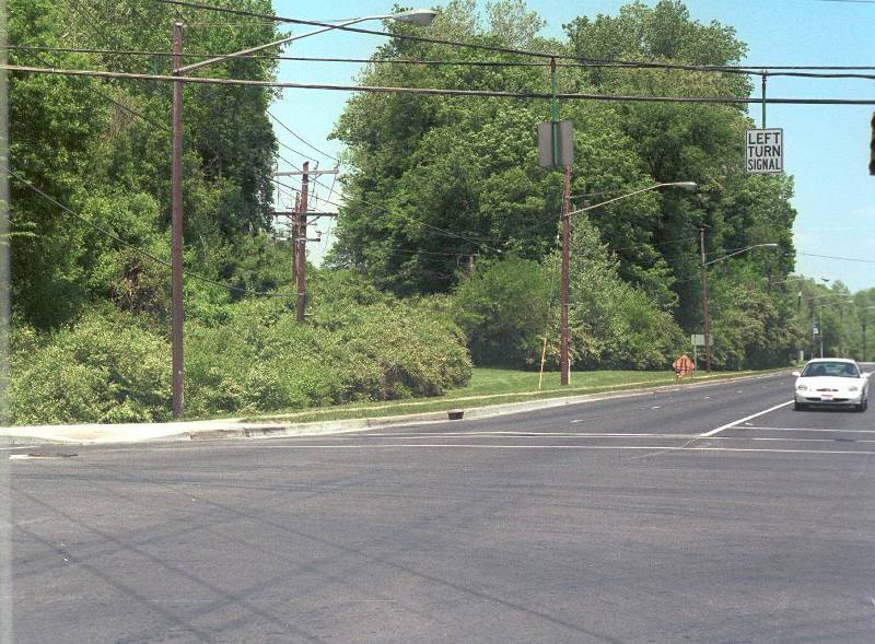
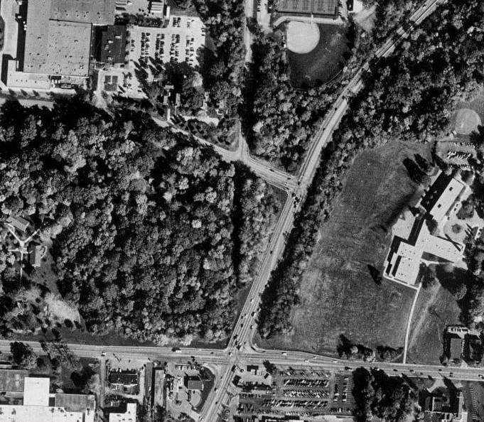
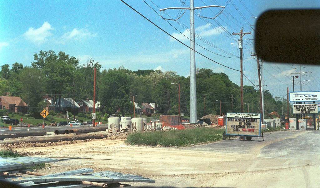
Updated 05/17/2004 - Duck Creek's Brother: Red Bank Road. Sorry no re-organization yet. I have to say, right now this site contains only about 25% of the material I have, including more aerials - but it does contain most of the best of the best stuff, in terms of historical views. What I am adding now are three contemporary photos. The first one is looking north, from the truncated end of Old Red Bank Road, where it would have crossed Madison. It doesn't take too much imagination to follow the gap in the trees up the hill, where just over the crest, you'd find the east end of Duck Creek Road. Today, Red Bank is the "Red Bank Expressway", a mis-named 4-lane road built to bypass much of the old road and form an interchange with I-71 just north of the Duck Creek terminus. Looking north, across the intersection Old Red Bank (ORB) crossed Madison at a 90 degree angle, here you can see how the Red Bank Expressway (RBEX) is angled more SW to NE. But the eye wants to follow the new road and it's barriers, and turn an angled intersection into a seeming 90-degree. Same view, but taken at the turn lane of the intersection. Is there pavement of Old Red Bank below those trees? I haven't braved the poison ivy to find out. Here is a very sharp 2000 Terra image of the intersection of Madison (E-W) and the RBEX, and the route of ORB is even more obvious from this angle. In the ground level photo, I'm standing near the bottom dead center of this image. The Terra also shows the east end of Duck Creek, almost before and after side by side. Duck Creek bends southeastward - the upgraded part of it, to tee into RBEX. Halfway down is the remaining portion of ORB heading north, and the 3rd side of that triangle is "Duck Creek Court", which is actually the original east end of Duck Creek Rd. It ends in a tree stand, a good 10 feet above the relocated ORB. The 1948 Fairchild aerial of this same spot is somewhat more barren looking - there's a farm where the parking lot and office building are today. Lastly, a photo about a mile to the south of Old Red Bank Rd., which is being torn to bits in order for the new Duck Creek box to pass underneath it. Near as I can tell, a meandering, flood prone section of the creek is being re-routed. The houses on OLD old Red Bank (yes, Red Bank Road once again parallels itself) on the left side are very reminiscent of the houses that once perched on the side of Grove Park, across from the Spanish section of Duck Creek. I will hopefully have a lot more photos to document the current alterations to Old Red Bank - a "brother" road to Duck Creek in every way, as it takes over following the creek for several miles, and a lot more of it has survived today.
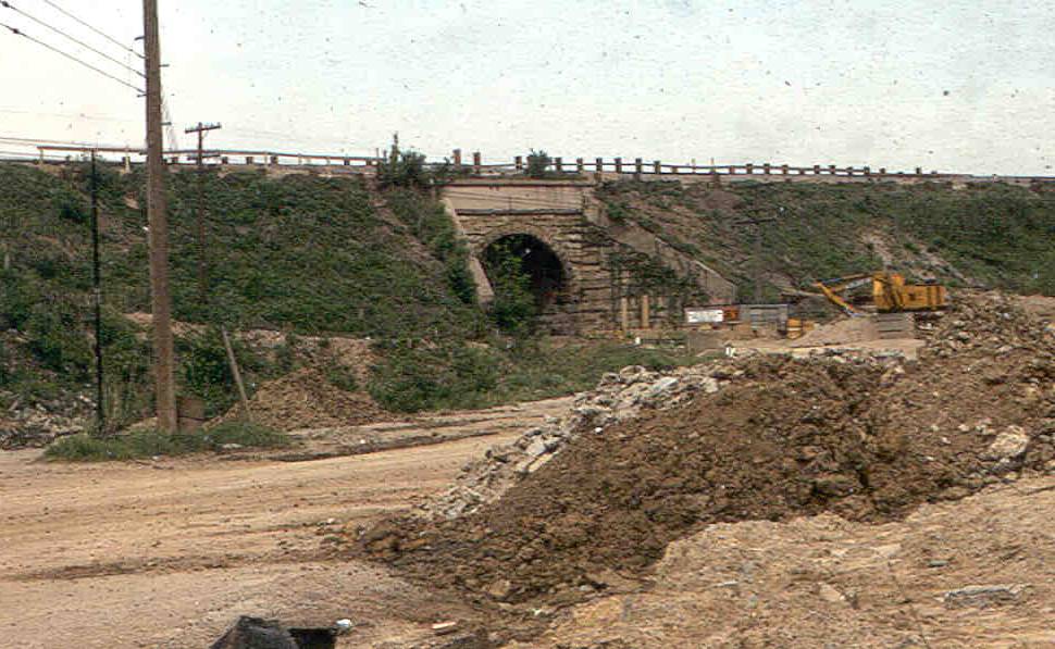
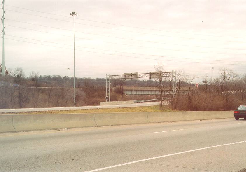
Updated 01/15/2004. This site is in need of being organized, with so many more photos to get lined up and posted. But this is too good not to post, even if it just adds one more out-of-sequence new update to the stack. Take a look here at this May, 1970 Photo of Duck Creek underpass at Ridge Ave. Photo by Jim Sicking, one of several who have taken an interest in this site and the first to contribute a much needed photo! Thanks Jim! This photo was taken shortly before the tunnel was destroyed - you can see the grading in the foreground. The photographer is standing near what was then the intersection of Marburg and Duck Creek. Today, to get the same vantage point, I had to park at the now dead end of Marburg and walk up onto the busy Ridge South/Norwood Lateral exit ramp to snap this photo of what it looks like today. I'm a good 10-15 feet above the same level, and quite a bit farther away than the 1970 photo - assuming the same general focal length lens was used. You can see the PRR tracks, which are a wonderful marker - railroad tracks don't move very often, and the artificial slope they were original built on, creating the need for the mouse-hole tunnel. Originally the tunnel was Duck Creek Road only, and it curved 90 degrees left into the tunnel from the south, then made a 90+ degree turn back east on the north side. Ridge Ave. ended at this juncture until the early 1950s when the dirt road then called Cushman on the south side was paved and extended to Madison Rd. and eventually merged with Marburg past Madison. It's my belief that the old portal would have been at the leftmost edge of the steel bridge you see in the 2004 photo. My memory is also faulty once again. I remembered this portal as having a brick lining much like the B&O tunnel featured at the entrance to this site, but in this photo it looks to be stone, inside and out. It was wider than the B&O, allowing two cars to pass but trucks still had to go through the center and took up the whole thing. One thing I hope to do when I get this site organized is to put all of the information I have on specific intersections together, so you can see the various views of Ridge & Duck Creek as it existed at various times, and the overlay of the 1948 and 2000 images together with the ODOT drawings will hopefully solidify the position of the old portal relative to the current road structure.
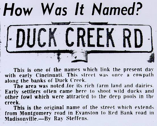
Updated 05/25/2003. Just a small addition, but I want to try and keep the site from going stale. This 1962 newspaper clipping is one of a regular series that ran in the Cincinnati Post and Times Star in the early 1960's explaining how various streets got their name. This one is from January 18, 1962.
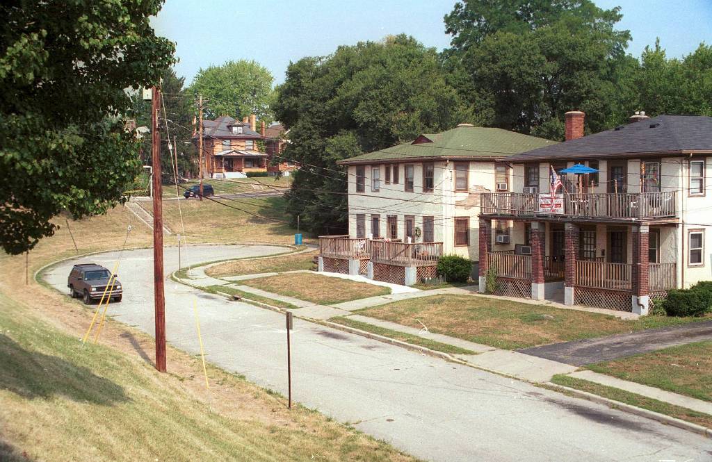
Updated 05/18/2003. The disorganization gets worse, but I figure it's better to keep updating than to let it all go stale. I've had these photos for a while, but haven't put them up yet. They are all present day photos that help to piece together the character of the Duck Creek valley and it's namesake two-lane. Eventually they will get into their own section, and it's my hope to eventually key all photos to maps and/or aerial images to put things in perspective. Photos by Tim Harman except as noted.
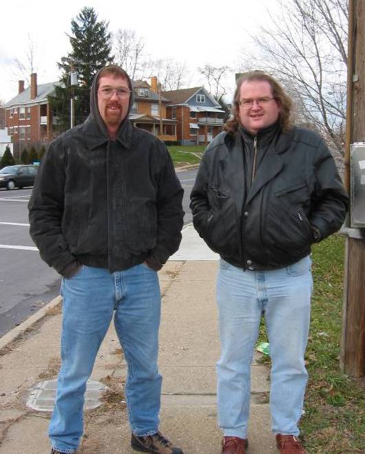 | Who is crazy enough to spend all this time documenting a road nobody liked that was killed 35 years ago? We are! Tim is the one with the beard, Andy (me) am the other one. I remember my dad's 45th birthday, August 1st 1960. I remember at the time, being less than three, wondering what I would be doing the day I turned 45. Standing on top of Five Points in Norwood freezing, that's what, while Chris took our picture and made the Five Points panorama. And yes it was fun! Slowly but surely, more people are seeing this site - Tom, Mike, Ron - all of you who have emailed, we thank you for your interest and assistance. But we need ground level photos of Duck Creek Road, from before or during I-71 construction. Of any location, any quality. Especially the lost areas of Junk Yard Alley and most of all, the underpass/arch at Ridge Rd. Email your comments, contributions, etc - we'd love to here from you, especially if you were a resident of or a regular traveler on Duck Creek Road prior to the obliteration. And if you have photos you are willing to share, we'll even buy you some Twinkies and a Pepsi at Five Points Shell. Maybe even a whole tank of gas if they are really good pictures! |
 | This is the shortest of the five sections of Duck Creek Road which still exist. I've named it the Beech-Melrose section, because it can only be accessed via Beech or Melrose Ave. on the northeast side of Five Points. The five points panoramic view (see 12/03/02 update) will show this section and hopefully put it in perspective. This view is looking west-northwest from the new Williams Ave. Duck Creek Road originally swung left here rather than right into the turnaround, and into Five Points. You can see Smith Road descending and then leveling off to meet Williams at the new intersection. |
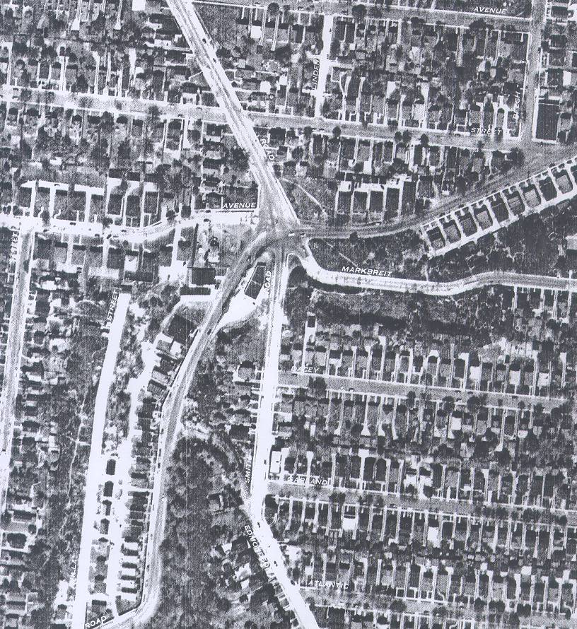
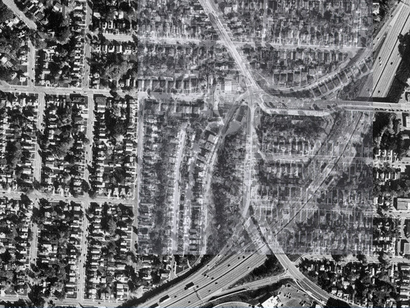
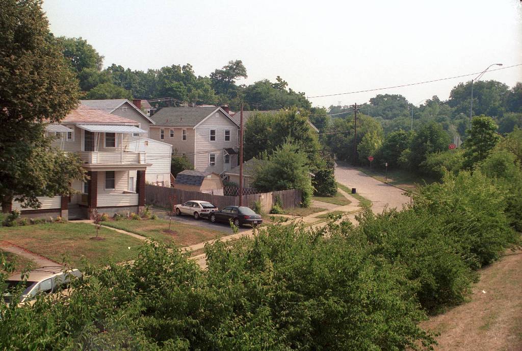 | Same vantage point, looking northeastward. In the 1948 aerial of five points, you'd be standing above the letter 'K' in the word 'MARKBREIT' about halfway between the two streets, looking northeast. | 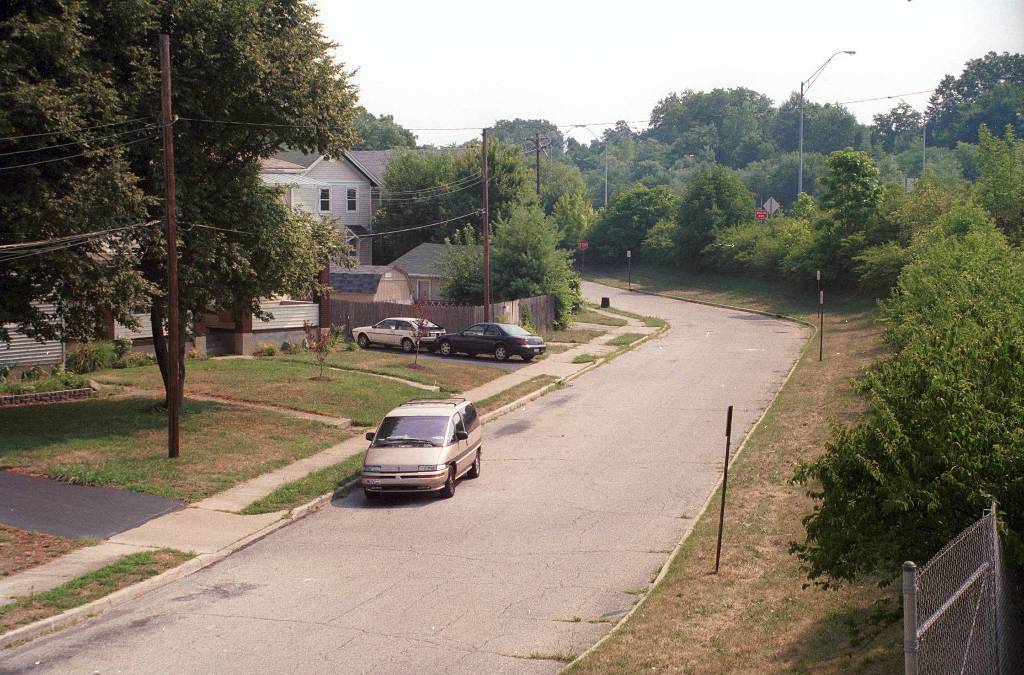 | Same general view as above, but the other side of the tree line. The gentle bend in the road at the very bottom of the picture is original. The sharper bend to the left is the result of truncating that section at what is now the off-ramp for southbound I-71 to Williams Ave. | 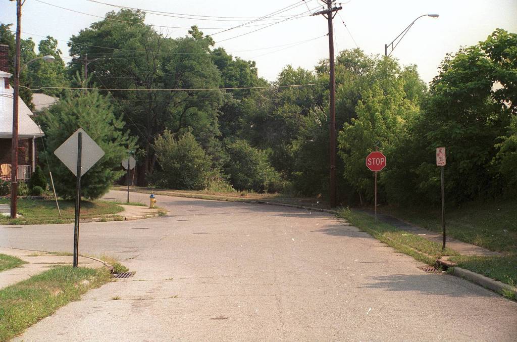 | Same general area, this is standing on the relocated Duck Creek. Melrose enters from the left, if you follow the road to the gentle left you are on Beech. Originally Melrose intersected Beech here, but Beech intersected Duck Creek a bit to the right out of this view. The full scans of the 48 aerial panel (the Five Points scan is only about 1/10 the area of the entire sheet) should clarify all of this eventually. |  | Had you been able to continue on past Beech, just a couple hundred feet ahead you could have made a hard right hairpin turn onto southbound Edwards Rd., and this is what you would have seen as you completed the turn. This is probably the best photo so far depicting the short but rapid drop to Duck Creek. Aside from the vehicles, this photo could have been taken in 1965. Farther up Edwards, everything has changed. | 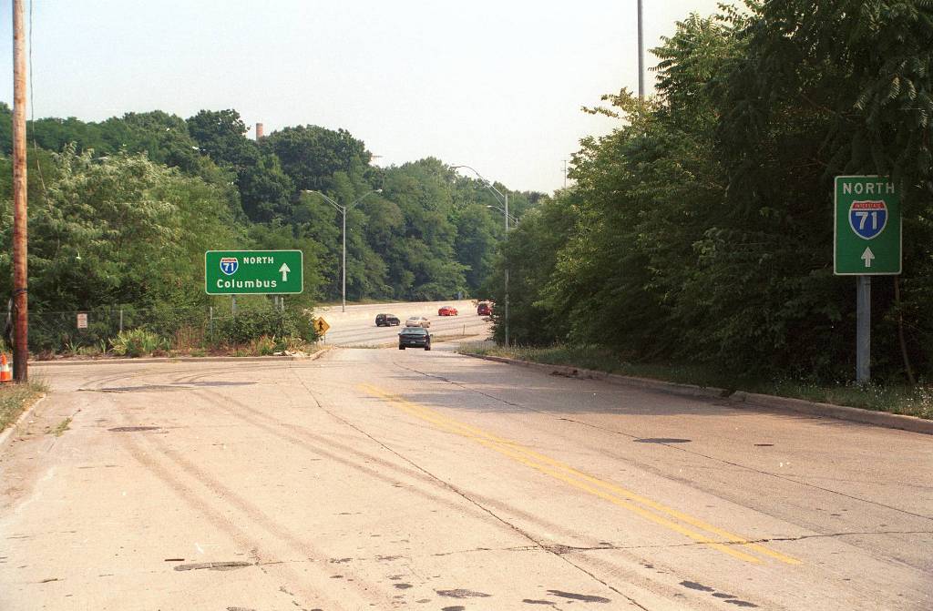 | Same location, looking the opposite direction. I-71 below is at the level of Duck Creek Road, so you can see how steep the drop must have been here, in a much shorter distance than the entrance ramp bending off to the right. This is one of those places where you can't miss the scar tissue from the freeway alterations - despite the aged concrete in the turnaround and the mature trees in what was once the middle of the wye convergence of these two old roads. On the right, behind the North 71 sign, would have been the Grandview apartments. Aerials show it to be a segmented building of a motel-like construction, but I have found no ground level photos to confirm my suspicions and lost memories. | 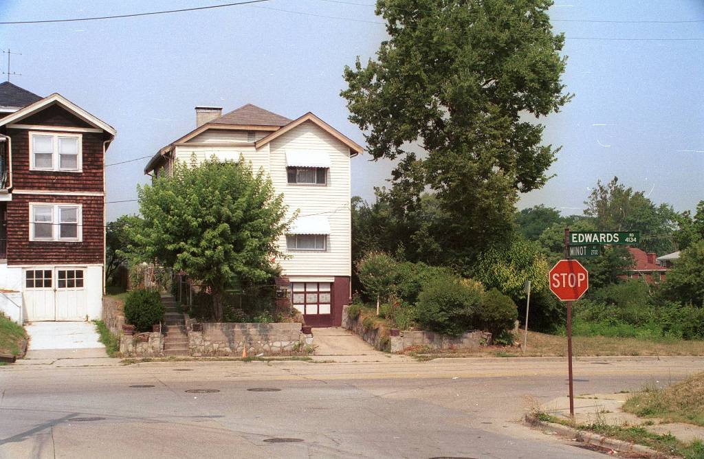 | The last house on Edwards, on the west side opposite Minot Ave, is the same as it was 35 years ago. The Grandview apartments were the only structure casualty on Edwards Road. To put things in perspective, the house below the Edwards sign is on the other side of I-71, on Beech. If you look at the Five Points Panorama and look east, you can see the backs of these houses on Edwards, although these two may be behind the trees - Need to make another trip back to see if they are visible or not. | 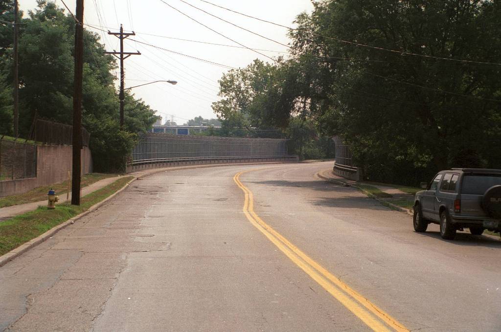 | The area of Duck Creek Road between Beech and the Trash Place is completely obliterated, as the main right-of-way of I-71 occupies the same space. Duck Creek dissappears at Beech, and doesn't re-appear until that little hook on the south side of the brick tunnel. This is what it looks like today, facing east on Robertson Ave. Duck Creek crossed Robertson at the far end of the bridge here, about 30 feet below. Except back then, it wasn't below - Robertson, like every other cross-street, did the dive to meet Duck Creek on it's own terms. In this 2002 view looking east, it's hard to picture it. This view is so vastly different from this 1965 Eastern Hills Journal photo that it stretches the imagination, although both photos are of essentially the same spot. The bridge over I-71 would be above the top of the gas station sign in the old photo. Unfortunately the grainy newspaper photo doesn't show the topology very well, but the decline has to be very steep here. | 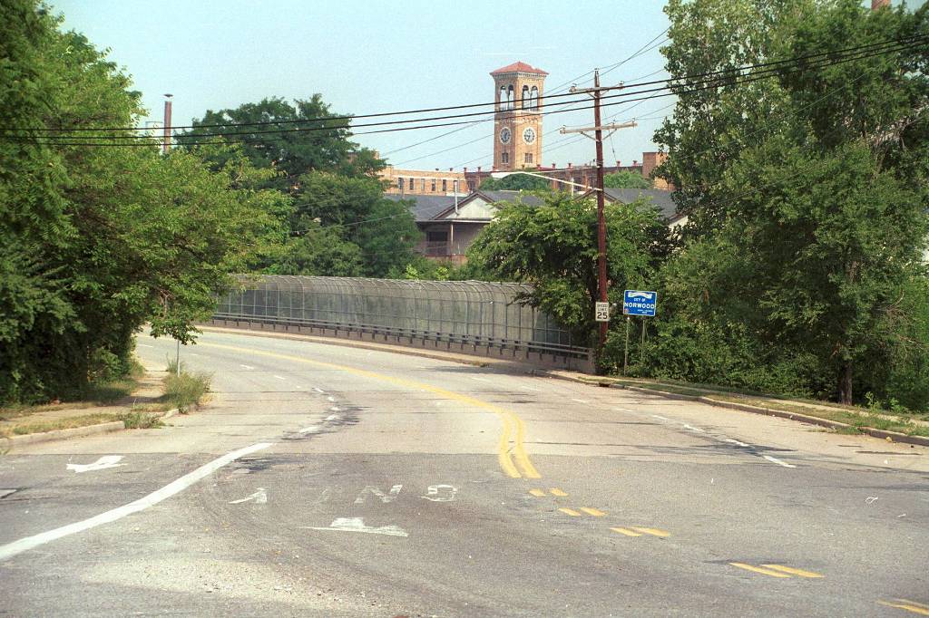 | Looking east/northeast from the intersection of Robertson and 28th. The telltale in this photo is the "City of Norwood" sign. Duck Creek Road served as the border between the two cities through much of it's length, and the sign's placement - just at the right burm of northbound I-71 - matches up precisely with my composite image showing Duck Creek crossing Robertson at this point. Although no trace of the old road remains, one can at least stand on this overpass and trace its path. Beyond the Trash Place, in the middle of the vast Ridge/Norwood Lateral/I-71 interchange, I have yet to find a vision of Junk Yard Alley. |
 |
| Ok, no vision - but a pasted together image from two scans of a not very good photocopy of the original 20x30 linen of the 1948 Fairchild aerial. I'd give a lot to have a large format darkroom at my disposal with the original negatives. This part of Duck Creek Road just plain does not exist any more. This is a large image, so you will need to scroll it horizontally to follow the road. It is not a complete view, the aerial itself begins at the Milacron RR overpass, but we'll get to that later. Lester Road from the north, between two junkyards, then a third junkyard, then Marburg from the south - very near where you can veer off the Ridge South or Norwood Lateral ramp onto Marburg today. Then a dirt road called Cushman, today this is the 4-lane Ridge Rd. Then the lost two-lane brick arch, invisible in the photo but no doubt its there. North of the Pennsy tracks, Ridge continues north, Duck Creek bends east and into the last mile, which still exists today. Compare to this newspaper view looking east from Lester Rd. The junkyards are gone, part of the road has been moved to a temporary road, and everything else is scraped down to the bare clay. |
Updated 05/06/2003. This site like it's subject is always under construction. The new domain name of duckcreek.org will hopefully allow some search engine listings, and easier linking to other Cincinnati history related sites. This is not the way the front end of this site should look. When I first posted this page nearly a year ago, it was just a linear stream of consciousness of what I knew of the subject at the time, and a few photos of interest. It long ago outgrew the single document format but being lazy, I haven't broken it down into components yet. Web development is not my favorite thing, but once I get going on it, I can spend many hours. Since this site was started, I have been able to document many facts about Duck Creek Road, but still have very few images of what it looked like from the ground, to a driver or pedestrian on the street. Easy enough to find and identify a specific house on an aerial, but it doesn't say much about what it looked like. Even though I still have nowhere near the material I'd like to have, I still have much that hasn't yet been loaded onto the site. Much of it to be scanned, a lot of drawings from the I-71 construction plans. And the intro portion of the site (as in, right here) almost reads upside down, because my latest knowledge is at the front of it. The "overview" part contains a bunch of erroneous or misleading facts which I've since improved upon, but I may save it in an archive somewhere just to illustrate how the whole process has been for me. So I leave you this early morning with a bit of creative visualization, lacking pictures, in the verbal form of A Drive Down Duck Creek Road.
First update on the new site. I pasted together this not-so-good comparison of the area between Robertson Avenue and Trash Place, from the 1956 aerial view enlarged to the extent possible, and the 2000 Terraserver. I had to rotate the 56 view about 3 degrees counter clockwise, and resize it almost 4x... not much resolution there to begin with. Anyway, it proves something I was wrong about. South of the tunnel (see the tunnel section) there is a little stump of road that cuts toward I-71, almost like a turnaround. Based on the 1956 view and other sketches, that appeared to be a relocation, and the actual road cut even more sharply right into the tunnel. Well one thing this new composite shows is that the path of the old road lines right up with this stump on the Terraserver image, so - it's actually a preserved piece of Duck Creek Road, unlike the rest of the USPC road beyond it. Here is the enlarged 1956 view for clarity and the clip from the 2000 Terraserver image.
Thanks to the very high quality 1948 aerials, I was able to create this Overlay of Five Points 1948 vs. 2000. The registration is pretty close around the intersection itself, toward the bottom of the view you can see Atlantic Avenue is slightly askew. Further down you will find links to the separate views.
Updated 12/03/2002. The newest addition is this panorama of Five Points as it exists today. Unfortunately while technology permits us to take a wonderful view like this, it doesn't (yet!) allow us to go back and take the same 360-degree panorama in, say, 1965. This is a large file, 2.5 megs. You can scroll left/right in a complete circle and also up and down which captures some important aspects to the topology.
Five Points Panorama - 11/30/2002, by Chris Tarnowieckyi
To find your way around, first pan right to find the Shell station. The view was taken from the NE corner of Smith and Williams, the Shell is on the NW corner. As you look at the Shell station, you are looking west. Smith Road is passing in front of you. Now look to the right and Smith Road goes uphill to the north. There are three original houses between the Shell and Melrose Ave, the next intersection. There were originally four houses as the 1948 aerial shows (see below). Now pan right across Smith Road. There is a yellow house which you can see is below the road level. Keep panning to the right, and downward and you can see the steep slope of fill that we are standing on, well above the original level of the intersection. That's a very short chunk of Duck Creek Road below, with several apartment buildings. The cul-de-sac is new, originally the road would have passed directly beneath the camera and through the intersection. Now look up in this same view, and in the distance you can see the exit ramp, which is the southbound exit for Smith/Edwards from I-71. Farther away you can see back of the houses on Edwards Road, gradually descending as the road goes northward. Today this is the entrance to northbound I-71, originally Edwards met Duck Creek in a Y not far out of this view.
Keep panning to the right and you are looking at the new part of Williams Ave, built next to the old Markbreit extension. On the south side of Williams is a chain link fence, which closes off the former Dacy Ave. section. Two years ago this was a closed loop consisting of a portion of old Dacy Ave, a connector paralleling I-71, and a portion of old Markbriet paralleling Williams. All of the houses and apartments inside this fenced area were demolished in the past 6 months, and recently even the pavement is no longer visible. This giant pile of dirt is slated to be yet another commercial development of some kind. But that's not all. See those houses in the background? A total of 77 more structures may be threatened by yet another "Rookwood" expansion, replacing some rather nice if modest older houses with more concrete and commercial. This area has apparently boomed as a commercial development due to the yuppie demographics of the surrounding area, but if they keep knocking down houses, there won't be anyone left in a reasonable distance to spend money at the next new megaministripmall. The battle is still going on, but if the developer wins, the entire area bounded by I-71 on the west, Williams on the north, Edwards on the east, and Edmondson on the south will be dirt-piled and concreted. I'd rather not see this happen.
Pan further right and we are looking up Edmondson hill where there is a CarX and a Midas side by side. Nothing like a little competition, eh? The other half of the Smith-Edwards exit is up the hill as the green signs indicate. The pale green houses are original of course. If we could go back even farther in time, to before WWII, Edmondson didn't even come here - it cut abruptly west somewhere between the CarX and Midas and intersected Duck Creek, as you can see on the 1948 aerial with the remnants and tree line visible. Lastly, pan a little farther right and you can see some stucco apartment buildings looking half buried... this is the beginning of Spanish Duck Creek, and of course originally we would have been looking straight at these buildings at ground level instead of on top of 15 feet of fill (when it's over 30 years old, is it still "fill"?) Originally Duck Creek came straight at you here, but now it intersects Williams behind the black SUV that is eastbound on Williams, almost invsibile in this view. Over the curb between Edmondson and the apartment buildings is the "Grassy Hole", which is just that - still showing some ground contours and a manhole in the middle of grass that used to be in the middle of Duck Creek Road.
A little bit more panning and you are looking west on Williams Ave. and then we're back to the Shell station where we started. This view by no means shows all there is to see at this location, but I was very impressed by how much detail Chris was able to pack into this panorama. It stands up very well to full screen display so don't hesitate to try it!
Updated 11/12/2002. This site is an ongoing work. I ultimately intend to include as much information as is practially possible here on the site, as it becomes available to me and as I secure permission when necessary to publish images. I also plan to leave some of the original text in place, because it reveals the whole process of research and discovery and why it is so interesting. I've already noted a number of corrections to be made, but I'd like to preserve the sequence of discovery which will evolve into its own story. Hard to believe I have been involved in this project for six months now, making trips to investigate sources when I have the chance, driving the territory looking for new and old clues, taking friends on the tour, and so on. I've recently encountered more people with interest and memories of Duck Creek that I'm planning to get together with to compare and share what knowledge and material we have. The current site division is based on the extant portions of Duck Creek Road today, and what was available at the time I started this site. My new plan is to divide Duck Creek Road into sections as follows:
1) East End - Montgomery to Dana-Vista
2) The Dana-Vista interchange - then and now.
3) Spanish Duck Creek - Dana-Vista to Five Points.
4) Five Points... Duck Creek's biggest and busiest intersection.
5) Five Points to the One-Lane tunnel, including Edwards and Robertson intersections.
6) The One-Lane tunnel.
7) Trash Place - Harris Ave.
8) Junk Yard Alley - Trash Place to Lester Rd, on to Marburg.
9) The Ridge/Cushman/Marburg/Duck Creek two-lane brick tunnel and intersection.
10) West End - Ridge to Red Bank
11) Following the Creek - Old Red Bank Road.
12) Following the Creek - Old Wooster Pike.
New stuff not yet categorized:
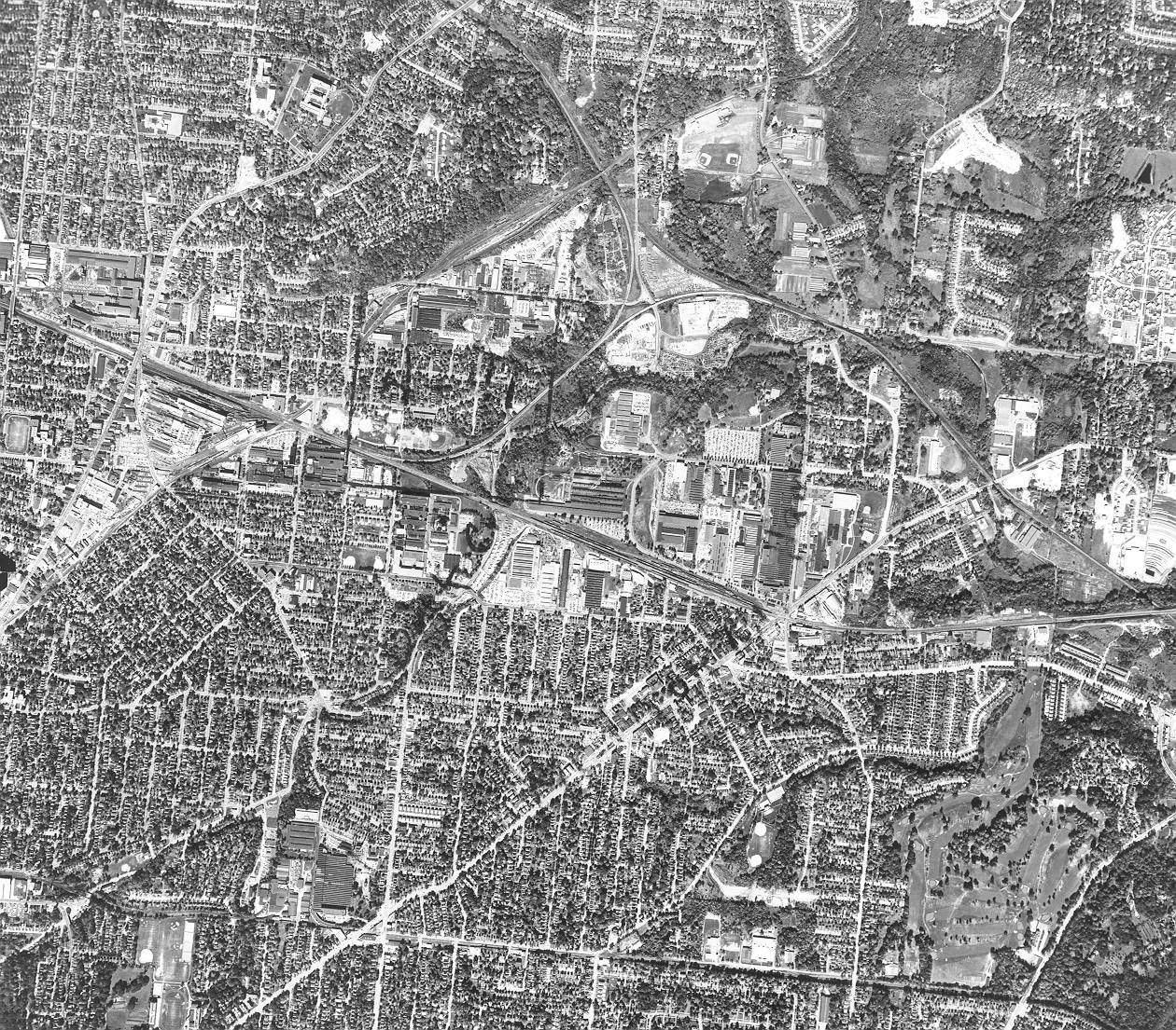
1956 Aerial View of the entire "lost miles" of Duck Creek. Not on the same scale as the awesome 1948 views, but it does show everything from Dana-Vista to Ridge, Kennedy and beyond all in one view. Upper right corner is a white, new looking grid like a TV test pattern of the 1950's. That is the ill-fated Eastwood Village apartment complex, which would be abandoned by the 1970's.
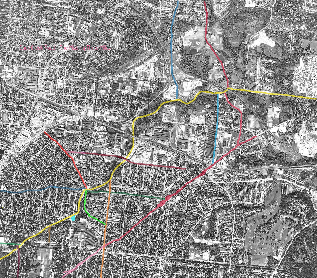
1956 Aerial View Color-Coded Follow the Yellow Brick Road - Duck Creek in
yellow emerges from the west end near Dana-Vista in this view. Follow it to the northeast as the missing
miles come back to life:
PURPLE: Vista Viaduct
GREEN: Dana
BROWN: Westgate
BLUE: Williams (Five Points)
GREEN: Edmondson (Five Points)
RED: Smith (Five Points)
DARK GREEN: Markbreit (Five Points)
ORANGE: Edwards
PURPLE: Robertson
One-lane tunnel under B&O RR
Trash Place
Underpass Milacron siding lead
BLUE: Lester Rd.
Junk Yard Alley
BLUE: Markbreit
RED: Ridge/Cushman south extension (built post-1948)
Two-lane tunnel under PRR
RED: Ridge north section
And on to the East End.
Lastly click here for an awesome view of Five Points in 1948. It just
doesn't get any better than this. Unfortunately 1948 was the last time a full aerial survey was done in this level of
detail until well after I-71 was completed. Clockwise:
9:00 Williams Ave.
11:00 Smith Rd.
2:00 Duck Creek Rd.
3:00 Markbreit Ave.
6:00 Smith Rd. Extension (Edmondson)
7:00 Duck Creek Rd.
This shot also illustrates why it's called Five Points. Notice the abandoned road which turns from Edmondson
west onto Duck Creek, south of Five Points. Originally Edmondson terminated here making the intersection
truly Five Points. Smith was extended south through the intersection to this point, and the original "hook" was
abandoned although you can still see what looks to be dirt and the tree line where it was. Compare to the 1956
view, where this is almost invisible. I have yet to find any trace of this original terminus of Edmondson
visible today, although the location was not trashed by I-71.
Terraserver image of Five Points today, from six down to four. To most drivers it's a rather ordinary intersection adjacent to a freeway interchange with the typical gas station convenience store. But the aerial view betrays it's past. Duck Creek Road has been swung a few hundred feet to the west to leave it out of the intersection, on the NE side it has been severed into a cul-de-sac. Road at new 4-points has been raised 12-15 feet above original grade, NE and SW corners are deep embankments. Old route of Edmondson would pass between what is now a Car-X and a Midas side by side. Five Points Shell sits on top of what used to be the northward jog in Williams, which has been straightened out.
The area bordered by the triangle of Williams (old Markbreit), Edmondson, and I-71 has been entirely obliterated in just the past 2-3 months.. but this October 2000 view shows it intact. The houses and apartment buildings are gone from what was once a severed section of old Markbreit that connected to Five Points, Dacey Road paralleling it to the south, and the road added after I-71 to connect them. Looks like it is to become yet another office park.
Part I - History and Overview
Most of us who live and work in any major city - especially one such as Cincinnati which lacks mass transit of any consequence - would find it hard to imagine life without freeways. But the Interstate Highway System is less than fifty years old from its inception, and many parts of it are much newer. Construction of freeways in older cities usually obliterated everything in their path as they were built. Old landmarks and intersections ceased to exist. Neighborhoods were severed right down the middle, often forcing one to travel several miles for what was formerly a 2-minute walk.
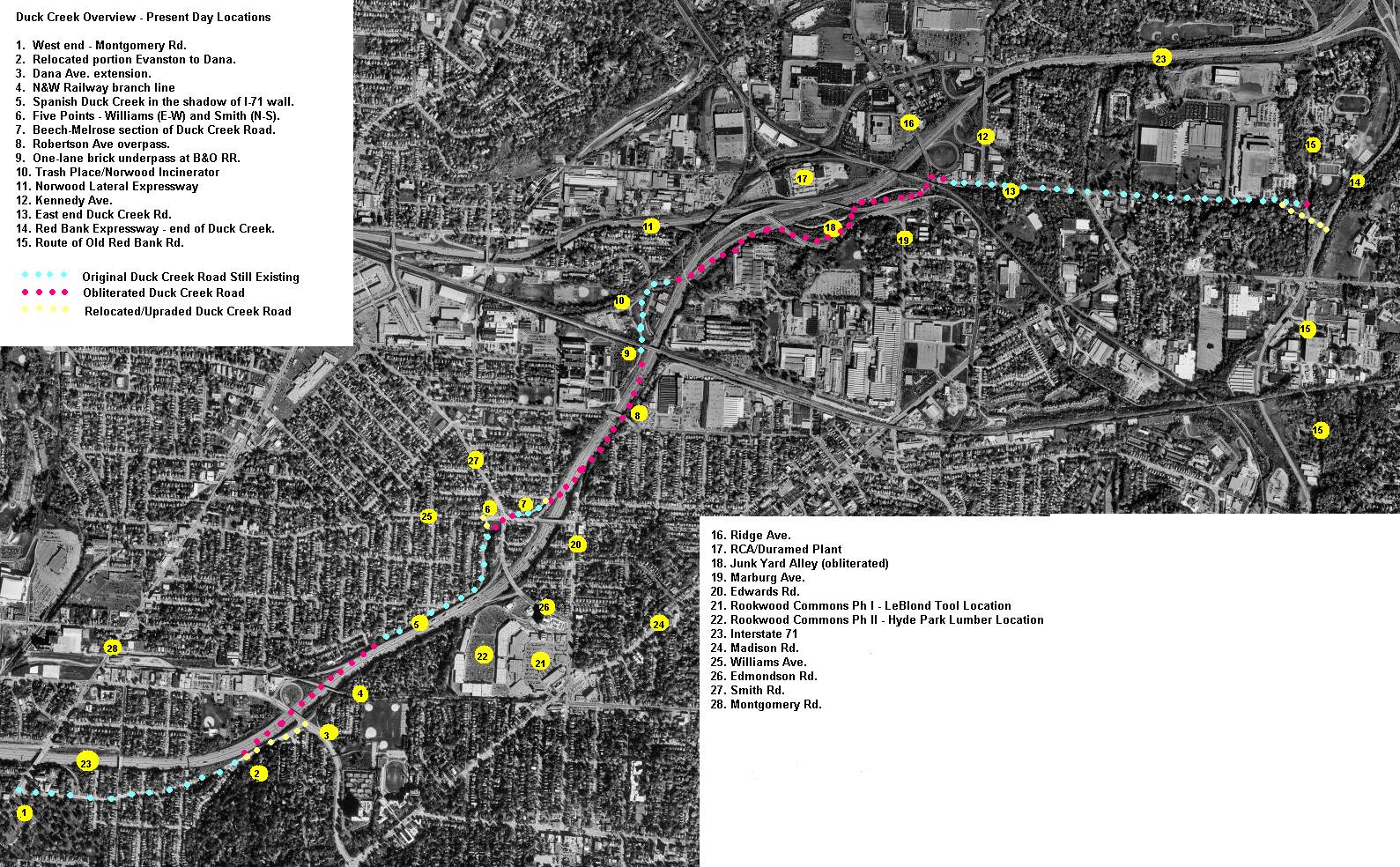
The construction of I-71 through Cincinnati began in the early 1960's, and the final section from Dana Avenue in Evanston to Reading Rd. downtown was opened December 20, 1974. I grew up in the Hyde Park suburb of Cincinnati, near Withrow High School. I-71 cuts a path from Montgomery Road eastward and northeast largely following the Duck Creek Valley. A very old 19th century road originally ran approximately 5 miles, from Montgomery Rd. in Evanston to old Red Bank Rd. in Madisonville. The westernmost mile and easternmost mile are largely intact, and have been upgraded to handle current traffic loads. The middle portion from Dana Ave. to Ridge Rd. is largely buried under I-71 today, although amazingly it still survives in three obscure disconnected pieces.
One could easily get lost in trying to visualize an entire city before interstate highways. Maps help, but don't show the topology. They don't show the houses, the businesses, the bridges, the tunnels, the neighborhoods, the intersections, the essence of life before the interstate. So the purpose of this page is to document my ongoing quest to breathe a little life back into that missing 3-mile section of Duck Creek Road, before the first bulldozers arrived.
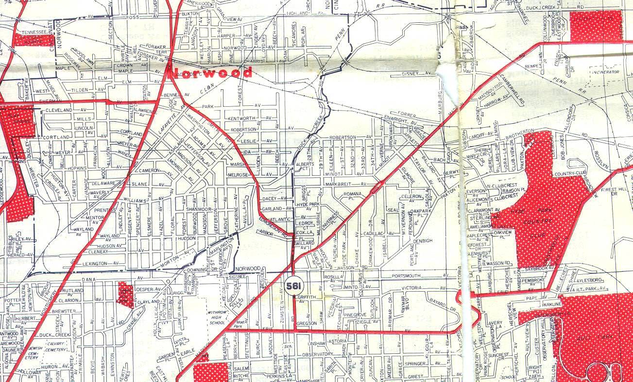
A 1961 Cincinnati Road Map shows at least 24 intersections or overpasses that more or less do not exist any more. Instead there are a handful of bridges over I-71 at key points. Beginning with the Vista Ave. viaduct and overpass and heading east/northeast: Vista, Dana, Burwood, S. Madison, Westgate, Jefferson, Grove, Hudson, Hires, Catherine, Avilla, the 6-way intersection of Duck Creek, Edmondson, Smith, Markbriet, and Williams, then Melrose, Beech, Marsh, Edwards, Robertson, Harris, Lester, Marburg, and Ridge. Or so I thought they did not exist any more.
Hires lane is not shown on this map; it was a short street which intersected Duck Creek on the south side between Hudson and Catherine and led to a construction company and lumber yard. Hires lane still exists as a tunnel under I-71, but in or around 1999 the entire area of the lumber yard and construction company was obliterated and filled to I-71 grade level or higher, as part of the Rookwood Commons shopping center expansion. The P.F. Chang's restaurant occupies the NW corner of this property overlooking the Hires Lane trench by 20 or more feet from the back. If one could walk through the gated Hires Lane tunnel, you'd find yourself in a narrow and very steep canyon between Grovedale Ave. to the west and the backside of Rookwood Commons to the east.
The SE corner of Hires and Duck Creek once hosted a Frisch's Big Boy restaurant. I don't have the exact date of its demise, but I know it was there until at least 1966. This site is now directly under I-71.
Today in this stretch, I-71 may be crossed on Dana, Edmondson, Williams, Robertson, and Ridge. Thats all folks!
Working up from the west end: Vista avenue which crossed Duck Creek on a viaduct and then intersected Dana just before it did the "Duck Creek Dive" now dead-ends into a concrete wall, below grade of the re-aligned portion of Duck Creek as it apparently dead-ends into Dana. Dana has been widened and made a full interchange with I-71, which it bridges, and then extended through a formerly wooded estate to connect to Madison Rd. opposite Observatory Ave. Burwood dead ends into a wall on the opposite side.
My first amazing discovery, hiding in plain sight all these years, was the stretch from S. Madison to Williams. The entire south side of Duck Creek Rd. is under I-71, but the road itself and the north side still exist below a 20' high concrete wall and some vegetation which totally hide its unique character from passers-by on I-71. Westgate now terminates in a quiet neighborhood overlooking from the south side, no indication that it ever made "the dive" and intersected Duck Creek between S. Madison(*) and Jefferson. But the north side, and it's unusual Spanish style houses remains intact. That was my first amazing discovery, because this is where I-71 squeezed into a space you wouldn't think it would fit.
* Important distinction between Madison and S. Madison: Madison Rd. is a major thoroughfare that somewhat parallels Duck Creek Rd. in the missing three miles. It was largely unaffected by I-71. S. Madison is a residential street on the north side of Duck Creek, no more than half a mile from the "big" Madison. There isn't much confusion any more I suppose, because today you just can't get there from here.
With Duck Creek severed and no longer a major artery, it was just "in the way" at the 6-way intersection. Edmondson was upgraded and widened, and straightened out a bit, and crosses Williams Ave. and becomes Smith Rd. Williams was straightened out and extended across to Edwards, orphaning tiny parallel strip that was formerly Markbreit, which now meets Williams at Edwards. The orphan strip is not long for this world, as yet another strip mall is slated to be jammed in to the triangle between Edmondson, Williams, and I-71, obliterating the remnants of Markbreit and Dacy Ave.
Duck Creek turns north, away from I-71 just past Avilla. To simplify the intersection and turn the 6-way into a 4-way, Duck Creek's intersection with Williams was moved about 150 feet west. Opposite the 4-way, a tiny section of Duck Creek dead ends 10 feet below the intersection, accessible only via Melrose or Beech. This 3-way intersection then dissappears... you guessed it, into a wall.
The former intersection of Edwards and Duck Creek - actually an upside-down Y, is now where Edwards tapers into an entrance ramp to northbound I-71.
Robertson Ave. used to make the dive, but now is a modern curving overpass over I-71. There is no trace of Duck Creek to be found.
Old Duck Creek Road resurfaces in a short forgotten stretch about 1/4 mile to the north of Robertson, behind the U.S. Playing Card Company. It would have jogged across I-71, then made a right turn into a one lane brick arch which is still standing. This tunnel had either a red/greed light or just a flashing red light, I don't remember which, and could only accomodate traffic one direction at a time. Yes, I did say this road was a "major artery". Its no wonder that not many people miss it, or have strong memories! This doesn't make my quest any easier. But the one lane tunnel was perhaps Duck Creek Rd's most tantalizing and unique feature, and it's presence - visible in winter from southbound I-71 if you know where to look - has teased me for many years.
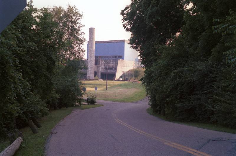
From the tunnel, Duck Creek passed by what is affectionately known as The Trash Place. It is a concrete and tile structure that probably served as an incinerator back in the days when they burned garbage. Its still there, although I have no idea who owns it or what it is used for, and I don't want to brave the NO TRESPASSING signs to find out. Past the trash place, Duck Creek intersects Harris Ave. near the old Norwood railroad station, which is still in use as a city building of some sort. It then turns abruptly right for a 100 foot stretch, and again vanishes into I-71. The remaining 3/4 mile or so to Ridge Rd. has been so completely obliterated that I am just beginning to be able to re-visualize it. While I-71 cut through Hyde Park, East Norwood, and Evanston with a scalpel edge, it's interchange with Ridge Rd., Kennedy Ave, Highland Ave, and the Norwood Lateral Expressway was one of the biggest bulldozer jobs ever seen around these parts. It completely stripped the landscape of all vegetation, structures, and topology. It affected close to one square mile and those areas not directly impacted have felt the change over the years. The Ridge interchange sits on Columbia Township land primarily, which means... NO CITY TAXES. A popular place for commercial establishments. Originally there was the "big" Ontario store (remember them?). It's now a Value City, and the area has exploded in recent years with Biggs, K-Mart, Wal-Mart a host of fast food joints, and now a Meijer, Target, and Sam's all occupying former Cincinnati Milacron land.
I have not been able to establish or prove if there was more than one brick arch tunnel on Duck Creek Rd. I have memories of as many as three - two single lane, and one double lane. Empirical proof of one single lane certainly exists, as you will soon see. The second tunnel may have been under the Cincinnai Milling Machine railroad siding, but the siding is much newer than the B&O Ohio Division line the first one passes under. I believe the double lane brick tunnel was at the intersection of Duck Creek and Ridge, with the two roads combining to pass through and then diverging their separate ways on the north side. Unfortunatly the same thing that makes the Ridge interchange a popular business spot makes it very difficult to find records or photos of it - it is not, and was not a part of any city or town, so things like Sanborn maps apparently don't exist for it.
Part II - Spanish Duck Creek
The preserved portion of Spanish Duck Creek runs from S. Madison to Williams. The road heads northeast along the I-71 retaining wall, then turns north and intersects with Williams Ave. a bit to the west of the former 6-point intersection. Click here to see terraserver image of Spanish Duck Creek. Start near bottom left and follow northeast along I-71 wall. Interchange at upper right is the south part of the Smith-Edwards ext, actually Edmondson Ave. At upper right corner you can see 4-way, formerly 6-way intersection and the relocation of Duck Creek to avoid the intersection.
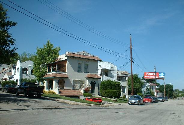
This stretch of road contains Spanish/Western architecture single and 2-family houses which are unique to the Cincinnati area as far as I can tell. Most of them seem to be pre-WWI vintage although I haven't been able to determine construction dates. Go one block off Duck Creek in any direction, and the architecture changes to very conventional Cincinnati brick and stucco. I find it interesting that Spanish Duck Creek is accessible only from the north via residential streets, or to the east via Williams. The last standing house on the western end at S. Madison & Duck Creek is only about 1/4 mile from the former intersection of Dana and Duck Creek, but ironically you can get off I-71 at the new, improved Dana Ave but it's almost impossible to get to Spanish Duck Creek from there. You must drive Dana all the way to Montgomery Rd, and turn back on Cleneay or another parallel street to get back there. It certainly makes for a cozy neighborhood, and not one that is going to see a lot of through traffic!
 | This is the beginning of the Spanish section, the intersection of S. Madison and Duck Creek. Notice the common architecture to the houses, yet each one is unique. Westgate would have intersected between the 3rd and 4th house in this view. |
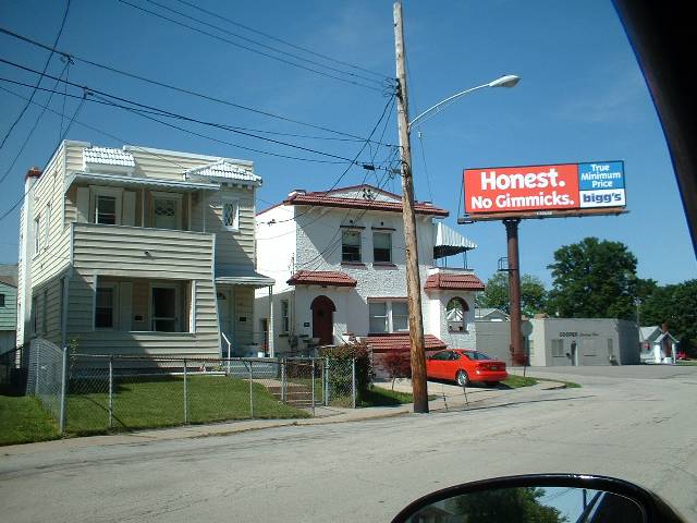
 | About a block further up, street at left is Jefferson. The application of aluminum siding spoils the original appearance of these houses, but probably has bought them some extended life because their stucco exteriors require upkeep to look good. |
 | Closer view of two of the houses. Street in foreground of Cooper Electric is Grove, behind it at 90-degree angle is Hudson. I think the Cooper building dates from the 1940's. |
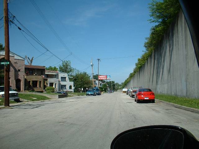 | Ooops... welcome to the year 2002! I-71 retaining wall where the other side of Duck Creek used to be. I did a drive by and you can see the tops of the houses through the greenery, just north of the Dana exit on the southbound side. If you don't look exactly for it, you'd dismiss it. And... from the Edwards ramp going south (off Edmondson) between the trees you can look right up Duck Creek, never noticed it all these years! |
 | Around the bend now looking north toward Williams Ave. This part is hauntingly familiar, the slight uphill climb toward the former 6-way intersection. The east side of the road is devoid of houses on this stretch, there are a few lots and businesses but mostly just trees and such separating it from the parallel stretch of Edmondson. |
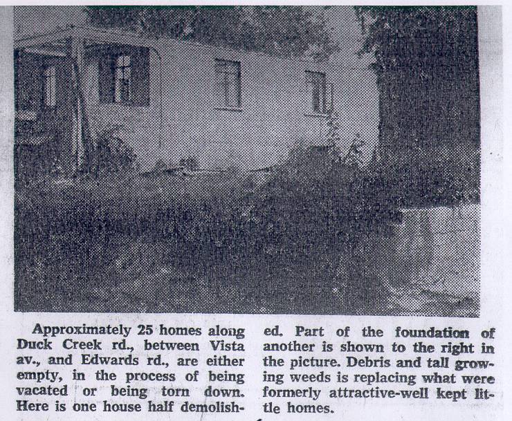 | No location is given for this partially demolished house. From the look of it, I'd guess it to be on the south side of Duck Creek Road in the Spanish strip, which means this house had the creek in its back yard, probably experienced several floodings in its lifetime, and is certainly now nothing more than a coordinate point someplace around the southbound side of I-71 approaching the Dana exit. |
 | This newspaper clipping from 1968 is the only photo I have found of the original 6-way intersection. It refered to here as "5 points" even though all my references indicate it was a 6-way, but in any direction you have 5 ways you can go, and there are five street names joined here. Dead ahead is looking south on Edmondson. Smith is in the foreground, and the original section of Spanish Duck Creek is to the right. Out of the picture to the left, clockwise from Smith, would be Duck Creek and then Markbreit. Counterclockwise from Smith, Williams is barely visible on the right. This is a scan of a photocopy of a 34-year old piece of newspaper in a scrapbook, but still reveals some useful information. |
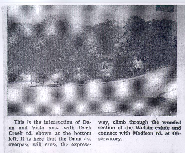 | This photo of the Vista Viaduct intersecting Dana reveals just enough to create even more mystery. Vista Ave. today dead-ends into a wall *below* the new/upgraded stretch of Duck Creek Road. The houses are at grade, which means Vista had to have climbed upward sharply and considerably to make this viaduct crossing of the Duck Creek and road, to intersect Dana in this bizzare triangle just before Dana turns south and does the Duck Creek Dive. Perspective is very hard to see in this photo, but the fact that Duck Creek Rd. is hard to see indicates it's kind of over the horizon of Dana's slope. This is one chunk of road I remember, but only after all traces of the Vista Viaduct had been removed. I rode my bike this way in the fall of '72, through the old intersection. Dana had already been extended to Madison, but crossed the unpaved grade of I-71 on a temporary road at the level of old Duck Creek. It was quite a drop into a hole, from the perspective of a 10-speed bike. Especially in the rain, when it was one of the largest mudholes around. |
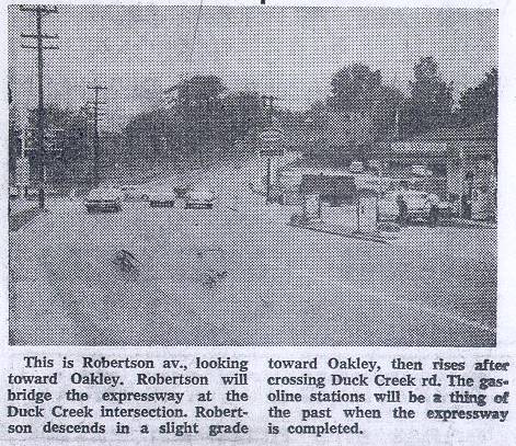 | Another clipping from the same article shows the intersection of Robertson and Duck Creek, looking east on Robertson. I will try to get a photo of the same spot from the same angle today, as it is almost unrecognizable. This location is about 1/2 mile NE of the Spanish section, with no trace of Duck Creek Road remaining in the area. |
 | New! 07/29/2002... this very nice aerial is actually only 1/4 of the total frame. I scanned only the portion pertaining directly to Duck Creek Road. This is the kind of thing I have been looking for, and it's a wonderful view and shows many things that aren't there any more quite clearly. That's Duck Creek Rd. going from the bottom right to the top left, looking west. The angled Spanish houses can be clearly seen, along with the neat row of small houses on the south side which are now buried under I-71. You can see a bit of Westgate Ave. descending from Marlington which parallels Duck Creek to the south (left in this view). Part of the small park still exists, a narrow sliver in the shadow of I-71. Completely and utterly obliterated is the Dana Coal Co. bins and the Vista/Dana interchange at the top left. N&W branch line's old trestle is also clear here. This view is from probably some time in the late 1940's. Houses on Grovedale (running left to right) are not all there yet, but the dirt road in the foreground is Hires Lane and the access to the various businesses that were there and the back way into Hyde Park Lumber. This is only about 1/4 of a HUGE aerial image which shows all of Hyde Park Lumber. This photo alone is worth several dozen circles and arrows, there is so much to see. I am hoping to find many more photos like this! |
Part III - The Trash Place
This short stretch of Duck Creek Road, barely visible from I-71 contains a wealth of interesting details and original "artifacts". Its ironic that it now is placed a few feet above I-71, what was once the bottom of a valley. Apparently I-71 was trenched out below grade to allow interstate clearances under the B&O railroad line, so the result is you can look UP at this section. Until I have a better and more accurate name for this stretch, I'll just call it The Trash Place, the area at the B&O underpass and Harris Ave. Click here to see terraserver image of the Trash Place area on-line.
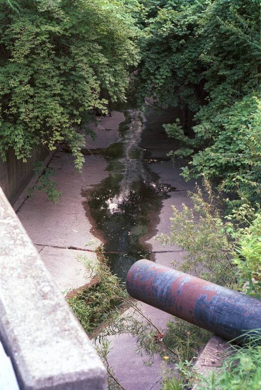
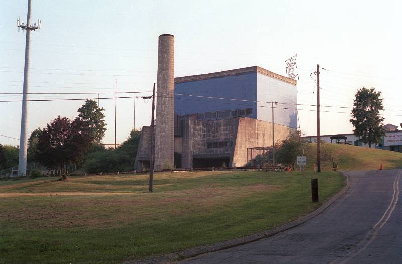 | Looking west at the old incinerator below Norwood rail station. We call this 'The Trash Place' although no trash has been burned here in decades. I am not sure exactly what this structure is currently used for - its not a recycling place because there is no material piled up. I am standing on Duck Creek Road, out of the picture to the left. Road to the right is entrance road to the incinerator and other buildings behind it. |
 | Looking SW at the Trash Place from the Harris intersection. Duck Creek Road in the foreground, curving gently left as the incinerator entrance goes right. The road going off to the hard left at the stop sign is an extension of Harris which crosses the creek channel to reach several buildings, then crosses back again to Duck Creek. The aerial view will clarify this lattice of roads. |
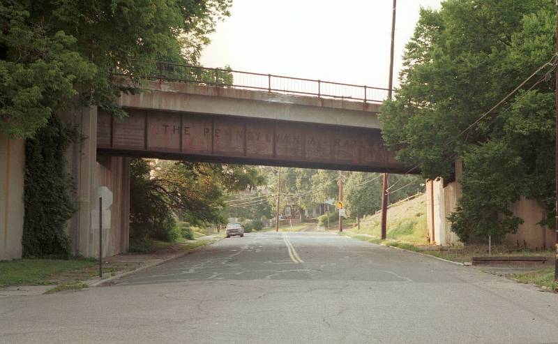 | Looking up Harris Ave. from Duck Creek. Bridge is Pennsylvania RR connection to the passenger station which is just up the hill to the right. |
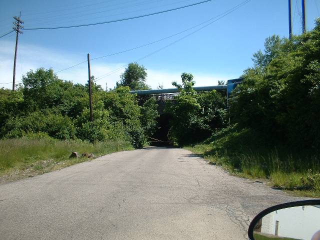 | Looking west on an amazingly original stretch of old Duck Creek Rd., although it has probably been repaved. Ahead shrouded almost completely is the one lane brick tunnel portal. It's no wonder you can't see this from I-71 any more. |
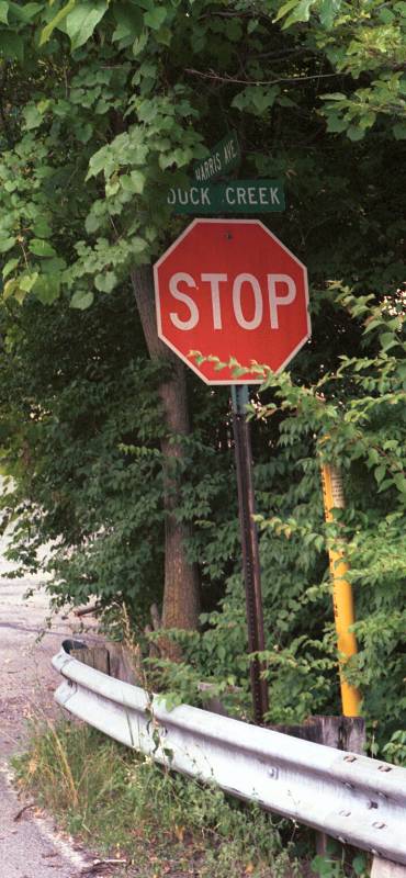 | Stop sign for Harris & Duck Creek is nearly hidden in the trees. You can't see it from any other angle, and in fact in my first few visits to this site I didn't see it. |
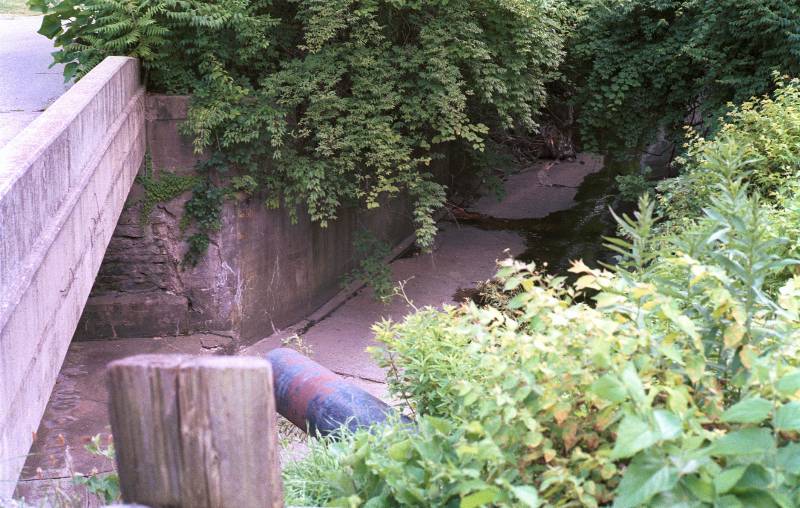
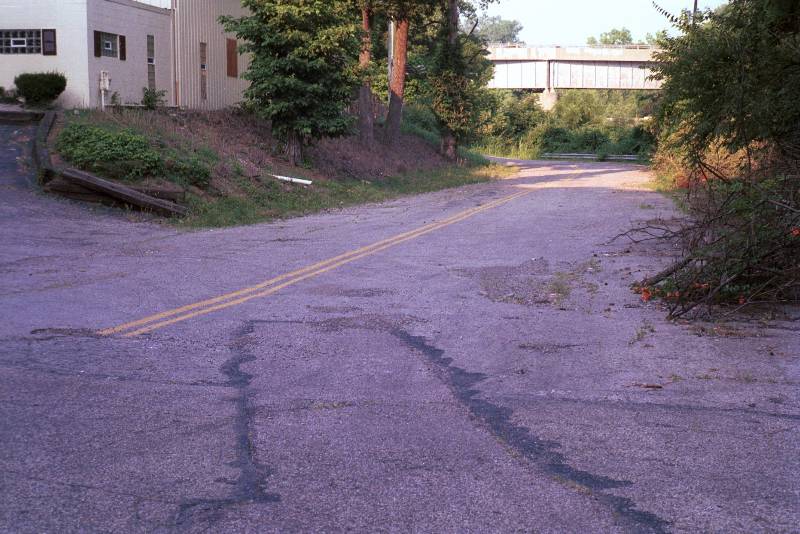 | This short strip, only 100-150 feet long is actually quite interesting because it has seen even less upkeep than the rest of the trash place area. Apparently it exists only for the one structure seen here and the driveway to it at the end of the strip. Duck Creek Road actually makes a fairly sharp bend at Harris, turning almost due eastward. |
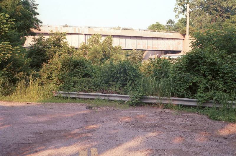 | The end of the strip... a railing, a few trees, and I-71. The railroad bridge is not quite as close as it looks, it is for the Cincinnati Milling Machine/Milacron railroad siding and Duck Creek Road passed under it straight ahead in this view. I have not been able to determine what type of underpass it was, it may have been a brick arch or a newer, more conventional design. |
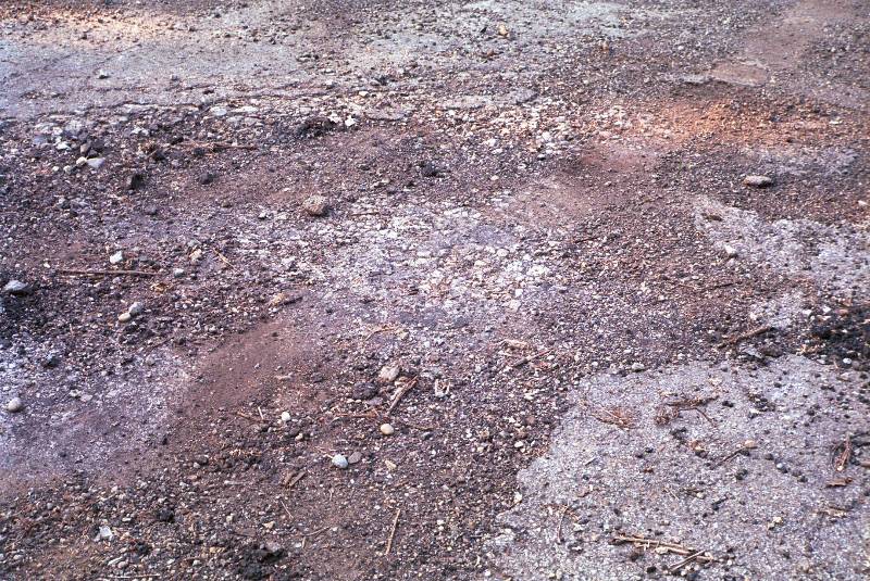 | Ok, so why did I take a picture of the asphalt? You can see several generations of paving here, as this stretch has obviously not needed a lot of upkeep in the past 35 years. Several layers of newer asphalt, and below that the rough, rocky asphalt that was used on suburban roads. Below that, Duck Creek was a gravel road, before that a dirt road, and probably originally an Indian trail. |
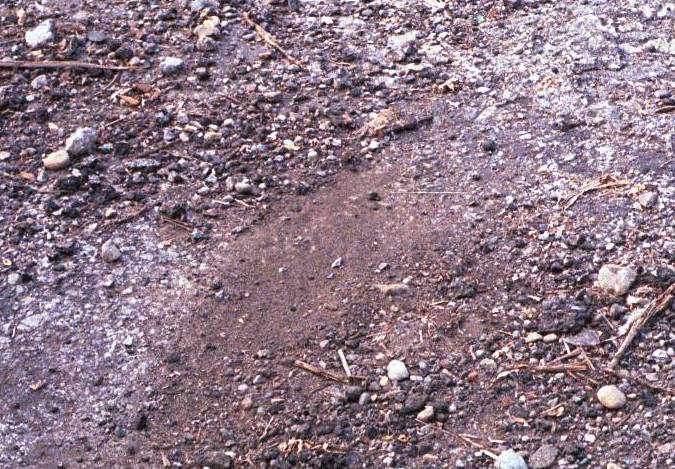 | Full resolution section of the asphalt shot. It's actually much more interesting in person! |
 | Looking mostly southward toward I-71 from the "Harris bypass" section of road. The creek is mostly in a concrete channel in the vicinity of I-71, but not always. Duck Creek flows generally eastward but meanders all over the place as post-glacial creeks are known to do. Creek flows toward camera in this view. This is looking from the Harris bypass south bridge. Yes, this piece of road crosses the creek twice in about 100 yards. As far as I can tell, Duck Creek Road never crossed the creek at all, always staying close to it's west/north bank. |
 | Same area, looking straight south - compare billboard position with previous photo. Here you can look right through the brick tunnel to the other side and see daylight, but due to the vegetation you can't really see much of the portal itself at this distance. A winter view of this same location might be interesting as well, but I'll have to wait 6 months to get it. |
 | The creek transitions back to natural as it passes under the north bridge of the Harris bypass and turns east, on the south side of the 150-foot stump of the old road featured above. |
 | Longer shot from the same vantage point, again looking almost due east, creek flowing away from camera. |
 | Where does the creek go from concrete to natural? Right here under my feet below the Harris bypass. Again aerial view helps clarify this, the creek briefly crosses under the "new" section of Harris, then back the other way as it closely follows the old Duck Creek Road. |
 | The other side (west) of the Harris bypass north bridge. |
 | Same location, looking south... see the abrupt bend in the creek which also occured in Duck Creek Road as it intersected with Harris. The concrete channel here is likely following the original creek path as much as possible. As it has been explained to me, it is easier to accomodate and work around the natural path, even when being concreted, than to try and alter Mother Nature's pre-ordained course. |
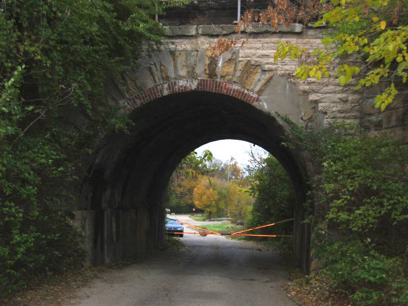
Part IV - The One-Lane Brick Tunnel
This cute little arch is probably the strongest memory I have of Duck Creek Road, riding with my dad as he patiently waited his turn, or with my mom fidgeting about what a hassle the whole thing was. It's part of the Trash Place area, but it's such an interesting artifact all by itself, I am devoting a separate section to it.
The brick arch is probably the oldest structure of any kind still extant in the Duck Creek Valley. It probably dates from the 1880's, or the time of the building of the railroad that is now the CSX (B&O) Ohio Division. At the time the arch was built, Duck Creek Road would have been a dirt road that may have evolved from an earlier trail. I will update this site with factual information as I come across it, but for the moment, the brick tunnel is just a fascinating relic.
The tunnel served at least until recently as a back entrance to U.S. Playing Card, probably for employees who lived on the north side of the expressway to avoid having to drive all around the place to get to work. The tunnel is presently gated as you can see in the photo, but my visits have all been on weekends so far - it may actually still be open to vehicle traffic during weekdays. I will find out.
The concrete reinforcements seem to have been added in the automobile age, to protect the tunnel walls. The black and yellow striping was probably painted in the mid 1960's Originally there was a stop light over the center of the arch, either a red/green light or just a flashing red, perhaps both at different times. Since this tunnel was probably the single largest bottleneck on the road, it probably was featured in more than one newspaper article of the times. Hopefully I will be able to find a photo of it as it looked in service, and perhaps of the other tunnel or tunnel(s) that my memory says were there.
 |
New!!
Quicktime 360-degree panorama from inside the tunnel. The other photos here were taken in April and May
2002. This movie was taken November 9, 2002. The outside of the portal is much less overgrown, but still
not visible from I-71. Chris Tarny took this panorama and stitched it together on his Mac,
and it plays for me on the current Quicktime player. It is a very large file (2.8 megs). Working on
creating a smaller version, and possibly reshooting it vertically to cover more of the inside surface.
Maybe I can convince Chris to shoot a panorama of Five Points as it looks today.

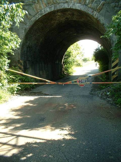
Looking south into the north portal of the tunnel. The lining and facing of this tunnel
is red brick, but it hasn't had a good cleaning or sandblasting in probably 35 years so
the color is primarily black, gray, green, and mold. The small gate keeps vehicles out,
but it's an easy walk-through. These first two photos were taken on 5/26/2002 with a digital
camera.
| 
Same view, stepping back a bit farther to take in more of the road and surrounding greenery.
| 
I returned on 06/22/2002 with a "real" 35mm camera to try and get more angles and
details at a higher resolution. These photos are scans of 35mm negatives at about 50%
resolution to keep web access reasonable. Notice how much difference 4 weeks makes
on the growth of the surrounding weedery.
| 
Closer view showing the concrete "crash padding", safety stripes, and you can even
make out an occasional patch of raw red brick if you look carefully.
| 
Stepping out of the south portal, this is the view. The road going off to the right is
the U.S. Playing Card entrance. I have no idea if this was connected in the pre I-71 days.
The stump turning to the left and vanishing into I-71 is the route of Duck Creek Road. It
angled across where I-71 is now, then turned to run parallel with it and crossed Roberson
Ave. slightly farther south. The building on the left is actually on the opposite side
of I-71.
| 
Apparently the south portal gets more sun than the north portal, and therefore some
of the brick facing actually still looks like brick!
| 
Another view of the south portal. In winter, both sides of the portal should still
be visible from I-71 if you know where and when to look, best if you let someone else
drive for doing this kind of sightseeing on the interstate!
| 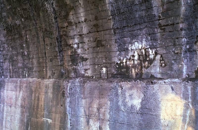
Close-up of the inside tunnel wall shows the minimal patching and repairing done
over the years. In spite of the neglect, the brick arch still seems to be quite
solid, a testimony to its builders who mixed the original mortar 120 or 130 years ago.
| 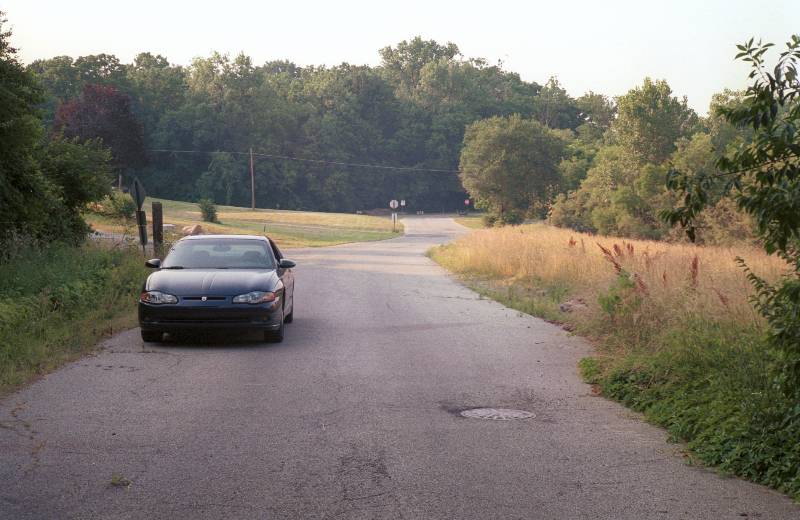
Looking out of the north portal at my car, and Duck Creek Road. Trash Place is out
of the picture to the left. Imagine this road, at 5:15 PM on a hot July day, packed
with cars, tow trucks, and dump trucks both directions. Not fun... but is it really that much
better sitting in a bumper-to-bumper jam on the interstate?
| |
Part V - The Ridge Rd. Intersection
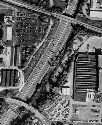
The entire original portion of Duck Creek Rd. between the eastward stump at The Trash Place and Ridge Rd. has been so completely obliterated that there isn't much to see today. However, I found a wonderfully teasing construction photo which for the time being is the only piece I have to offer, but it has some very strong reference points to connect it with current Terraserver satellite images. I have only begun to study this photo. It unfortunately does not show the actual intersection of Duck Creek and Ridge, but it clearly still existed when it was taken. I believe the date of the photo is 1971. It is an aerial view looking eastward with Lester Rd. across the bottom in the foreground and Duck Creek Road winding forlornly through scalped and scraped landscape, where it intersects with Marburg Ave. but vanishes from view as it curves into Ridge. Ridge Rd. itself can be seen snaking down at the top of the photo, much as it does presently. In the upper left quarter, Duck Creek Road's east portion which is still intact today can be seen heading off toward Red Bank. I have scanned this image larger than the others to reveal as much detail as possible, but it is still a 3rd generation copy. I'd love to have an 8x10 of the original... as well as any other shots this photographer may have snapped that same day!
This image can be easily coordinated with the Terraserver Image of Ridge from October, 2000. Three elements tie the views together nicely: the RCA/Duramed building, the railroad tracks, and the creek bed itself which shows up as a white concrete trench on the Terraserver image, apparently following its exact original path. Rotate the newspaper photo 90 degrees clockwise to put it in the same orientation as the Terraserver photo.
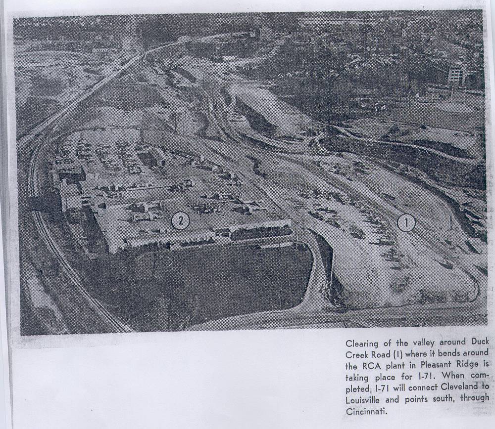 | There is a LOT going on in this photo, besides the two circled points the caption describes. At the very bottom right is the intersection of Duck Creek and Lester, which no longer exists. Lester now terminates at the driveway into the "RCA Plant" the caption mentions. This is now a Duramed facility, but other than the roof hardware, today looks exactly the same right down to the entrance road, parking lot shape, and even the circular turnaround in front. I suspect that Duck Creek Road has been straightened out in the area of the number "1" circled, and the original portion that hugged the creek bank has already been obliterated. This is kind of typical for interstate construction - maintaining the old route with temporary roads for as long as practical. It is also consistent with my 1961 map which shows the road following the creek line here, not a straight line east from Lester. The railroad tracks which sweep across the left side of the view are still there today, in the exact same place. The primary difference being several new underpasses for Ridge and I-71 and various ramps and loops. |
Part VI - Other Nearby Artifacts
This section will be expanding, as I photograph various structures and roads which are not part of old Duck Creek Road but are close by and representative of this suburban industrial valley.
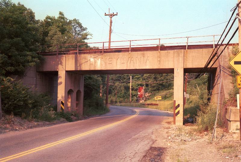 | Pennsylvania railroad bridge over Highland Ave, near Lester Rd. This is one leg of the wye which connected the PRR New Castle District through Norwood Station and onto the B&O where it continued on to Cincinnati. Highland Ave. originally terminated at Lester Rd., which is just out of the view around the corner. In the old days, a right turn on Lester would have taken you to a part of Duck Creek Road that is completely gone today. |
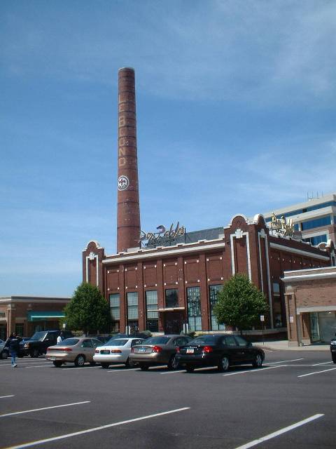 | The second-last remaining portion of the former LeBlond Tool Co. factory complex. Don Pablos built a restaurant in here (with 30 foot ceilings and industrial steel work and ducting left in place) and it became a theme for future construction which attempted to duplicate the look. This one is authentic, as is the smokestack. The rest of LeBlond has been obliterated by Rookwood Plaza, with one other exception (see below). |
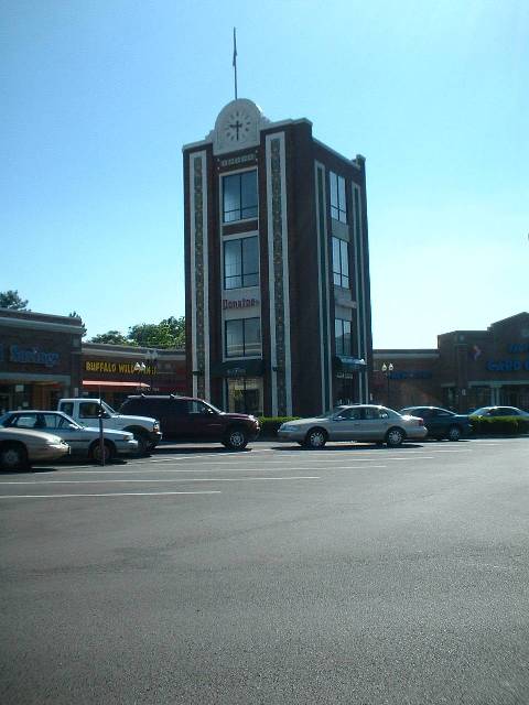 | The clock tower of LeBlond's complex now stands alone about 100 yards opposite the Don Pablos. Rookwood Plaza/Commons now occupies all of the corner of Madison and Edwards, the former property of LeBlond, Hyde Park Lumber, and the construction company off Hires Lane. |
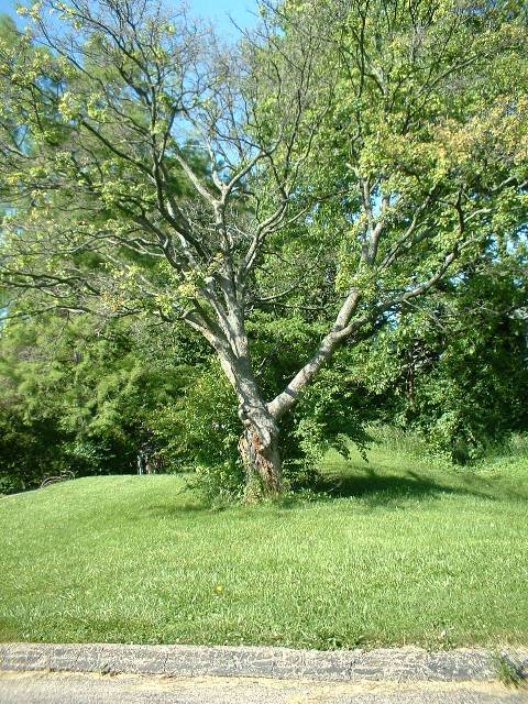 | The Withrow Climbing Tree. Has grown up a bit and the original lower climbing limbs are missing by various mishaps, but amazingly this old thing has survived standing by itself. It was the first tree I ever found that was strong enough to climb and also had low enough large branches to get hold of - for a kid anyway. |
Part VII - Driving Directions to These Sites
There are five disconnected sections of Duck Creek Road that can be reached today.
Section 1 - Duck Creek Road West End
From I-71 North:
1. Exit at Dana/Montgomery. This puts you on Duck Creek between Dana and Montgomery.
From I-71 South:
1. Exit at Dana Ave.
2. Turn left onto Dana from exit, cross over I-71.
3. Right on Duck Creek.
Section 2 - Spanish Duck Creek
From I-71 North:
1. Exit at Smith/Edwards.
2. Left from exit ramp puts you on Edmondson northbound.
3. Left on Williams (first traffic light).
4. Immediate left on Duck Creek, across from Shell station.
From I-71 South:
1. Exit at Smith/Edwards.
2. Right from exit ramp puts you on Williams westbound.
3. Proceed through intersection with Edmondson.
4. Immediate left on Duck Creek, across from Shell station.
Back way to Spanish Duck Creek (convoluted but interesting):
From I-71 North:
1. Exit at Dana/Montgomery.
2. Turn left from exit ramp onto Duck Creek Rd. (west end).
3. Left on Dana.
4. Stay on Dana all the way to Montgomery Rd. Right on Montgomery.
5. Right on Cleneay (2nd street)
6. Left on Regent
7. Right on Hudson
8. Right on S. Madison
9. Left onto Duck Creek at bottom next to wall.
From I-71 South:
1. Exit at Dana Ave.
2. Turn Righ from exit ramp onto Dana.
3. Follow steps 4-9 above.
(3) Beech/Melrose Strip
From I-71 North:
1. Exit at Smith/Edwards.
2. Left on Edmondson from exit ramp.
3. Proceed through intersection with Williams, Edmondson becomes Smith Rd. (Shell station on left).
4. Right on Melrose.
5. Right on Duck Creek - dead ends under NE corner of Smith & Williams.
From I-71 South:
1. Exit at Smith/Edwards.
2. Right on Williams from exit ramp.
3. Right on Smith at Shell station.
4. Right on Melrose.
5. Right on Duck Creek - dead ends under NE corner of Smith & Williams.
(4) The Trash Place
1. From I-75 or I-71 take Norwood Lateral Expressway (Signs say "562 Norwood")
2. Exit Montgomery Rd.
3. From eastbound 562, turn left and cross over to Norwood Ave and turn right; from westbound 562, turn right onto Norwood Ave. from exit ramp. 4. Norwood Ave. tees into Beech, turn right on Beech.
5. Beech tees into Harris, left on Harris.
6. Follow Harris down hill past Norwood station and under RR bridge to Duck Creek.
(5) Duck Creek Road East End
From I-71 North:
1. Take Ridge south exit (first at Ridge interchange).
2. Turn left on Ridge at end of exit ramp, cross under interstate and RR.
3. Veer immediate right on Duck Creek. 1-mile stretch will take you to Red Bank Expressway.
From I-71 South:
1. Take Red Bank exit. This puts you onto "Red Bank Expressway" directly.
2. Turn right at first traffic light onto Duck Creek. Duck Creek dead-ends at Ridge, you can't get to Ridge directly from Duck Creek westbound.
Part VIII - Wants and Needs
At this point my urban archaeology project is just beginning. I have done a fair scouting and photographing of the existing artifacts, but there is still much to be covered including the east and west end strips, and more on the Spanish houses. What I need are photographs - the higher quality the better - of any points on Duck Creek Road before or during I-71 construction. Any piece of information, any photo can be revealing. In particular, I need photos of the brick tunnel at the Trash Place in service, photos of any other tunnel(s), photos of the Ridge Rd. intersection, photos of the Edwards Rd. intersection, better photos of the 5-points, Robertson, and Dana/Vista intersections. Almost anything would be helpful, even if it's just a newspaper clipping. If anyone reading this is a former resident of any of the obliterated areas, or even a current nearby resident with a good memory (or maybe a camera and a curiousity back then!) I would love to hear from you. This project is entirely a personal history quest, to document the kind of things that often get completely forgotten in time because they are not particularly well-loved or famous. There are plenty of pictures of Coney Island, the riverfront, bridges, steamboats, Crosley Field, and the inclines and every railroad facility even contemplated and even the abandoned subway is very well documented. Duck Creek Road, and its urban industrial creek valley, gas stations, junkyards, ancient archs, and wacky, out-of-place houses is to me every bit as interesting as these more famous sites, if nothing more than because it remains largely a mystery today.
Please email me with any information, comments, or questions: andyduck@gp30.com